
“Tauktae” to intensify into severe cyclonic storm in next 6 hrs
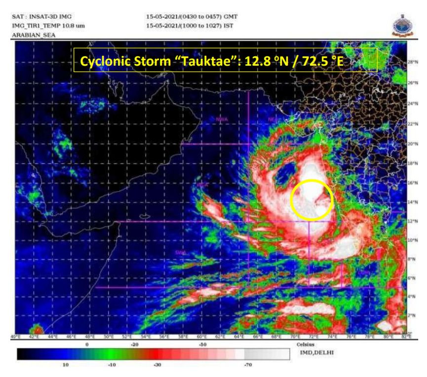
New Delhi: As per the National Weather Forecasting Centre of the India Meteorological Department (IMD), the Cyclonic Storm “Tauktae” (pronounced as Tau’Te) over east central and adjoining southeast Arabian Sea moved north-north-westwards with a speed of about 11 kmph during past six hours and lay centred at 0830 hours IST of today, over east central and adjoining southeast Arabian Sea near latitude 12.8°N and longitude 72.5°E, about190 km north-northwest of Amini Divi, 330 km south-south west of Panjim-Goa, 930km south-southeast of Veraval (Gujarat) and 1020 km south-southeast of Karachi (Pakistan).
It is very likely to intensify further in to a Severe Cyclonic Storm during next six hours and into a Very Severe Cyclonic Storm during the subsequent 12 hours. It is very likely to move north-north-westwards and cross Gujarat coast between Porbandar & Naliya around May 18 Afternoon / evening.
Warnings:
(i) Rainfall:
Lakshadweep Islands: Light to moderate rainfall at most places with heavy to very heavy falls at isolated places over northern Islands on May 15 and heavy falls at isolated places on May 16.
Kerala: Light to moderate rainfall at most places with heavy to very heavy falls at a few places and extremely heavy falls at isolated places on May 15, heavy to very heavy falls at isolated places on May 16 and heavy falls at isolated places on May 17.
Tamil Nadu (Ghat districts): Light to moderate rainfall at many places with heavy to very heavy falls at isolated places on May 15.
Karnataka (coastal & adjoining Ghat districts): Light to moderate rainfall at most places with heavy to very heavy falls at a few paces and extremely heavy falls at isolated places on May 15 and heavy to very heavy falls at isolated places on May 16.
Konkan & Goa: Light to moderate rainfall at most places with heavy to very heavy falls at a few places over south Konkan & Goa and heavy to very heavy falls at isolated places over north Konkan on May 15 and heavy to very heavy falls at a few places over Konkan & Goa & adjoining Ghat areas on May 16 and heavy falls at isolated places on May 17 over north Konkan.
Gujarat: Light to moderate rainfall at many places very likely to commence over coastal districts of Saurashtra from May 16 afternoon, at many places with heavy to very heavy falls at isolated places over Saurashtra & Kutch and extremely heavy falls at isolated places (in Junagarh & Gir Somnath Districts) on May 17 and with heavy to very heavy falls at a few places over Saurashtra & Kutch with extremely heavy falls (≥ 20 cm) at isolated places (Porbandar, Devbhoomi Dwarka, Jamnagar & Kutch districts) on May 18.
West Rajasthan: Light to moderate rainfall at many places with heavy to very heavy falls at isolated places very likely on May 18 & 19.
(ii) Wind warning
Squally weather with wind speed reaching 45-55 kmph gusting to 65 kmph is very likely over Maldives area and equatorial Indian Ocean during next 06 hours.
Gale wind speed reaching 75 – 85 kmph gusting to 95 kmph is prevailing over east-central Arabian Sea and adjoining southeast Arabian Sea and Lakshadweep area. It is likely to increase over east central Arabian Sea becoming 120-130 kmph gusting to 145 kmph from May 16 morning.
Squally wind speed reaching 50-60 kmph gusting to 70 kmph along & off Kerala coast on May 15.
Squally wind speed reaching 50-60 kmph gusting to 70 kmph likely along & off Karnataka south Maharashtra & Goa coasts on May 15 and Gale winds speed reaching 60-70 kmph gusting to 80 kmph along & off Maharashtra –Goa coasts on May 16.
Squally wind speed reaching 40-50 kmph gusting to 60 kmph likely over northeast Arabian Sea and along & off south Gujarat & Daman and Diu coasts on May 17 morning and gradually increase becoming Gale winds speed reaching 150-160 kmph gusting to 175 kmph over northeast Arabian Sea from May 18 morning and along & off Saurashtra & Kutch coasts (Devbhoomi Dwarka & Porbandar) and 120 -150 kmph gusting to 165 kmph over Kutch, Porbandar, Junagarh, Jamnagar districts of Gujarat from May 18 afternoon / evening for subsequent 06 hours.
(iii) Sea condition
Sea conditions will be very rough over southeast Arabian Sea and adjoining
Lakshadweep – Maldives area & equatorial Indian Ocean during next 06 hours.
Sea condition over east central Arabian Sea will be high to very high on May 15 & very high to Phenomenal on May 16 and over northeast Arabian Sea on May 17 & 18.
Sea conditions will be rough to very rough over Comorin area and along & off Kerala coast on May 15, very rough to High over east central Arabian Sea along & off Karnataka coast on May 15 and Maharashtra – Goa coasts on May 15 & 16. It is very likely to be very rough to High over northeast Arabian Sea along & off south Gujarat coast from May 17 morning and very high to Phenomenal from May 18 morning.
(iv) Storm surge warning
Tidal wave of about 2- 3 m above astronomical tide is likely to inundate coastal areas of Morbi, Kutch, Devbhoomi Dwarka & Jamnagar districts and 1-2 meters along Porbandar, Junagarh, Gir Somnath, Amreli, Bhavnagar and 0.5 to 1m over the remaining coastal districts of Gujarat.
(iv) Fishermen Warning
Total suspension of fishing operations over east-central and adjoining southeast Arabian Sea and along & off Kerala – Karnataka – Goa – Maharashtra coasts.
Total suspension of fishing operations over northeast Arabian Sea and along & off Gujarat coast from May 17.
The fishermen are advised not to venture into southeast Arabian Sea, Lakshadweep – Maldives areas, east central Arabian Sea along & off Karnataka coast, east-central Arabian Sea and along & off Maharashtra – Goa coasts and into east-central& adjoining northeast Arabian Sea along & off Gujarat coast till May 18.
Those who are out at Sea over north Arabian Sea are advised to return to the coast.
(vi) (A)Damage Expected over Devbhoomi Dwarka, Kutch, Porbandar, Junagarh, Gir Somnath &Jamnagar districts of Gujarat:
Total destruction of thatched houses/ extensive damage to kutcha houses. Some damage to pucca houses. Potential threat from flying objects.
Bending/ uprooting of power and communication poles.
Major damage to Kutcha and Pucca roads. Flooding of escape routes. Minor disruption of railways, overhead power lines and signaling systems.
Widespread damage to salt pans &standing crops, Blowing down of bushy trees.
Small boats, country crafts may get detached from moorings.
Visibility severely affected.
(vi) (B) Damage Expected over Amreli, Rajkot & Morbi districts of Gujarat:
Major damage to thatched houses/ huts. Roof tops may blow off. Unattached metal sheets may fly.
Minor damage to power and communication lines.
Major damage to Kutcha and some damage to Pucca roads. Flooding of escape routes.
Breaking of tree branches, uprooting of large avenue trees. Moderate damage to banana and papaya trees. Large dead limbs blown from trees.
Major damage to coastal crops.
Damage to embankments/ salt pans.
(vii) Action Suggested:
Total suspension of fishing operations.
Judicious regulation of rail and road traffic.
People in affected areas to remain indoors.
Movement in motor boats and small ships unsafe.
Comments are closed.